Research
Ortho-Fuse: Orthomosaic Generation for Sparse High-Resolution Crop Health Maps Through Intermediate Optical Flow Estimation
Overview Research area: Computer vision for precision agriculture — specifically orthomosaic generation from aerial drone imagery using optical flow estimation. Technical level: Intermediate. The pape
- arXiv
- 2510.10360
- Published
- 2025-10-11
- Authors
- Rugved Katole, Christopher Stewart
AI summary
Overview
Research area: Computer vision for precision agriculture — specifically orthomosaic generation from aerial drone imagery using optical flow estimation.
Technical level: Intermediate. The paper combines photogrammetric concepts (overlap ratios, ground control points, structure-from-motion) with a pre-trained neural network for frame interpolation, but presents them at a level accessible to readers with general machine learning background.
Scope: The paper proposes Ortho-Fuse, a framework that inserts RIFE-generated synthetic aerial frames between real drone captures so that orthomosaics can be built from imagery with less inter-image overlap, and evaluates the resulting maps against conventional reconstruction.
What This Paper Is About
Building an orthomosaic — a single stitched map of a field — normally requires drone flights with 70-80% overlap between consecutive images, because stitching software needs enough shared features to align them. That forces long, expensive flight missions, even though the downstream AI crop-health models only need about 20% field coverage. Ortho-Fuse's goal is to break that dependency by synthesizing intermediate images between sparse frames, artificially creating the feature correspondences the stitcher needs, and thereby producing usable orthomosaics from sparser data.
Key Contributions
-
Ortho-Fuse framework: An optical flow-based paradigm for generating orthomosaics from sparse aerial imagery, using the Real-Time Intermediate Flow Estimation (RIFE) model to synthesize transitional frames between consecutive captures and linearly interpolating GPS metadata so the synthetic frames are usable by standard photogrammetry software.
-
Demonstrated overlap reduction: Experimental validation reporting a 20% reduction in minimum overlap requirements — orthomosaics generated from 50% inter-image overlap with quality comparable to traditional methods requiring 70-80% overlap.
-
Three-tier comparative evaluation: A structured comparison of (a) baseline reconstruction from original images at standard overlap, (b) reconstruction using exclusively RIFE-generated synthetic frames, and (c) a hybrid of original plus synthetic frames — assessed through visual quality, Ground Sample Distance, and NDVI crop-health maps.
-
Adoption-barrier analysis and future directions: A synthesis of why AI-driven agricultural monitoring stalls in practice (cost, trust, complexity, technical limits) plus proposed research directions, including diffusion-based orthomosaic synthesis for overlap below 30%.
Main Findings
-
Overlap requirement reduced by 20%: Ortho-Fuse generates orthomosaics with only 50% inter-image overlap while maintaining reconstruction quality comparable to traditional methods that require 70-80% overlap.
-
Finer ground resolution from synthetic and hybrid data: Average Ground Sample Distance measured 1.55 cm for the original dataset, 1.49 cm for the synthetic-only dataset, and 1.47 cm for the hybrid dataset. The paper interprets the smaller values as greater image granularity and better orthophoto quality.
-
Improved seamline integration: Visual comparison of representative orthomosaic sections showed the synthetic and hybrid approaches produced improved seamline integration and reduced artifacts relative to the baseline reconstruction.
-
Crop health analysis preserved: NDVI-derived crop health visualizations computed from all three orthomosaic variants showed consistent agricultural analytical capabilities, indicating that synthetic frames do not break downstream health assessment.
-
Test setup: Evaluation used two aerial imagery datasets collected at controlled 50% side and front overlap with a Parrot Anafi drone flying at 15 meters above ground level. For every pair of original images, three synthetic images were generated, yielding a pseudo-overlap of 87.5%. All orthomosaics were processed with OpenDroneMap Web ODM using identical parameter configurations, and ground control points were established across each test field for quantitative accuracy assessment.
-
Sparse AI health mapping context: The paper cites prior work showing learning models for crop health assessment can operate with coverage as low as 20% of the whole field while achieving over 80% accuracy in predicting the whole-field health map — the efficiency gain that orthomosaic generation requirements currently negate.
-
Baseline performance limits reported from prior work: The paper cites comparisons of six photogrammetric software packages across forest conditions showing average RMSE values of 1.24 m for raw orthophotos, with precision improving to approximately 0.2 m only after extensive post-processing.
-
Not reported: The paper does not report numerical GCP-based accuracy metrics (such as RMSE) for its own three orthomosaic variants, nor a quantitative NDVI agreement score between baseline, synthetic, and hybrid maps. These are characterized visually rather than numerically.
Methodology in Plain English
The pipeline has four stages.
First, a drone collects aerial imagery with inter-image overlap that can vary between 25% and 50%. Second, the collected frames are passed through the RIFE network, which uses an architecture called IFNet to directly estimate optical flow between consecutive frames and generate in-between frames. RIFE is used as a pre-trained model with no domain-specific retraining for agriculture — the authors note it relies on deterministic, motion-guided synthesis rather than the stochastic sampling of GANs or diffusion models, and that this gives motion consistency and computational efficiency suitable for real-time use.
Third, the synthetic frames are given metadata. Because generated frames have no GPS coordinates or camera parameters, the authors linearly interpolate GPS positions between the surrounding real frames and reuse the original camera parameters. Without this step the frames would be unusable by photogrammetry software.
Fourth, the augmented dataset is fed into OpenDroneMap (ODM) to produce the orthomosaic. In the reported experiments, three synthetic frames were inserted per original image pair, lifting an effective 50% overlap setup to a pseudo-overlap of 87.5%. The authors then compare baseline, synthetic-only, and hybrid reconstructions using visual inspection, Ground Sample Distance, and NDVI.
Why This Matters
Impact on research: The work reframes orthomosaic generation as a temporal interpolation problem rather than a pure feature-matching problem. It connects a real-time video interpolation model to a photogrammetric pipeline and shows the two can interoperate if metadata is reconstructed carefully. It also documents the specific ways current tools fail on sparse agricultural imagery — repetitive crop patterns causing 30-50% initial outlier ratios and 5-15% image incorporation failure rates, and structure-from-motion algorithms requiring 75%+ image overlap and delivering 2-5 cm horizontal and 3-4 cm vertical accuracy without ground control points.
Real-world applications:
- Low-cost field scouting: Farmers using sparse scouting flights can obtain a full-field orthomosaic instead of partial imagery, matching the way AI health models already work from roughly 20% coverage.
- Crop health visualization for decision-making: NDVI maps derived from Ortho-Fuse orthomosaics give growers the intuitive visual overview they rely on, rather than raw sparse predictions.
- Reduced flight time and data processing load: Fewer images per field means shorter missions and less downstream computation; the paper notes orthomosaic processing already requires 65-145 minutes for 1,030-image datasets, multiple days for 77,000+ images, and 50+ GB RAM.
- Compatibility with incumbent tools: Because Ortho-Fuse feeds OpenDroneMap, it can slot into existing pipelines — the paper names Pix4D, Agisoft Metashape, OpenDroneMaps, and DJI Terra as the industry-standard platforms exhibiting degradation on sparse data.
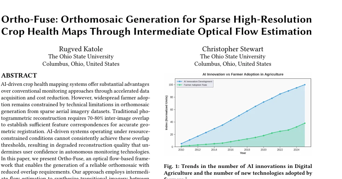
Industry relevance: The paper frames adoption as a trust and cost problem, not only a technical one. It reports that adoption remains at only 27% of U.S. farms despite demonstrated yield improvements of 15-30%; that 52% of farmers cite high upfront costs and 40% are uncertain about return on investment; that only 26% of rural farms have adequate broadband connectivity for real-time AI processing; and that the average farmer age is 58 years with 38% reporting insufficient technical expertise. A method that lowers data collection cost while preserving the familiar orthomosaic output targets those barriers directly.
Future Directions
-
Diffusion-based orthomosaic generation: The authors propose image patching through diffusion models as a path to robust orthomosaic synthesis from sparse high-resolution crop health maps with overlap requirements below 30%, potentially addressing structure-from-motion limitations via GPS-embedded patch reconstruction.
-
Video-generation models for trajectory modeling: They suggest fine-tuning advanced diffusion-based video generation models, exemplified by Nvidia Cosmos, to model drone trajectory dynamics and the temporal-spatial ground movement between discrete image acquisitions, using interpolated video sequences as training data for orthomosaic synthesis.
-
Hybrid semantic and object-level motion modeling: The current optical flow approach degrades when inter-frame semantic similarity is low, and fails under occlusion, sudden illumination changes, or discontinuous object trajectories. The paper calls for hybrid approaches incorporating semantic understanding and object-level motion representation.
-
Automated pipelines, real-time quality assessment, and edge deployment: The authors point to the convergence of GPU acceleration, edge computing, and generative approaches as enabling transformation, contingent on resolving orthomosaic bottlenecks through automated processing and real-time quality assessment.
Target Audience
Researchers and practitioners working at the intersection of computer vision and precision agriculture — particularly those building drone-based crop monitoring pipelines, photogrammetry tooling, or sparse-data reconstruction methods. It is also relevant to agricultural technology developers and agronomists evaluating whether AI-driven monitoring is operationally feasible at reduced data collection cost, and to researchers studying technology adoption barriers in digital agriculture. Readers need some familiarity with orthomosaics, aerial imagery, and optical flow to get the most from the methodology section.
Authors’ abstract
AI-driven crop health mapping systems offer substantial advantages over conventional monitoring approaches through accelerated data acquisition and cost reduction. However, widespread farmer adoption remains constrained by technical limitations in orthomosaic generation from sparse aerial imagery datasets. Traditional photogrammetric reconstruction requires 70-80\% inter-image overlap to establish sufficient feature correspondences for accurate geometric registration. AI-driven systems operating under resource-constrained conditions cannot consistently achieve these overlap thresholds, resulting in degraded reconstruction quality that undermines user confidence in autonomous monitoring technologies. In this paper, we present Ortho-Fuse, an optical flow-based framework that enables the generation of a reliable orthomosaic with reduced overlap requirements. Our approach employs intermediate flow estimation to synthesize transitional imagery between consecutive aerial frames, artificially augmenting feature correspondences for improved geometric reconstruction. Experimental validation demonstrates a 20\% reduction in minimum overlap requirements. We further analyze adoption barriers in precision agriculture to identify pathways for enhanced integration of AI-driven monitoring systems.